This article recently appeared in Sporty’s Air facts section. It actually received a few comments. There are a two typos on their site but that’s show biz.
Here’s the direct link Sporty’s
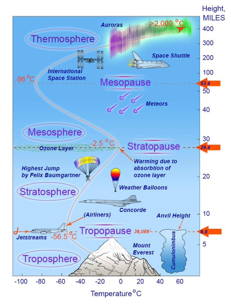
Diagram found in Doug’s co-authored book: Pilot Weather: From Solo to the Airlines. It hints at an isothermal layer at the tropopause but does not depict a potential inversion.
When referencing the tropopause, pilots and weather types converse using the truncated version, trop. But it rhymes with rope, not top. I am unsure why trope wasn’t used.
You are probably wondering why you are reading about the intricacies of the tropopause – where the first two layers of the atmosphere meet. After all, your single-engine piston aircraft struggles to climb to 10,000 feet, and Sporty’s readership caters primarily to aircraft below the altimeter setting region of 18,000 feet. However, you may be training to fly aircraft that soar higher, or being an airline pilot is your destiny. Perhaps you are flying a business jet that pokes up to great heights (frequently above an airliner), or you want to impress your peers by estimating the height of a developing thunderstorm because you peeked at the tropopause height coded on high-altitude weather charts. Flight training and flying opportunities are transpiring at warp speed, so if cruising at flight levels is where you want to be, read on!
The suffix pause denotes a boundary among the four layers of the atmosphere. The first pause is the tropopause dividing the troposphere and stratosphere. There, jet streams corkscrew the globe like atmospheric snakes (think meandering air currents with extraordinary velocity), and where turbulence lurks. Airline pilots strive to bestow passengers with a smooth ride, so knowing where the tropopause is in relation to the aircraft’s flight level is a must.
The illusive height of the tropopause is higher near the equator than at the poles. As you near the equator, tropopause heights reach approximately 55,000 feet, so you won’t be flying over the equatorial tropopause unless you pilot the S71 spy plane or sat in the Supersonic Transport Concorde before 2003. The tropopause is why thunderstorm tops flatten and spread out, resembling a blacksmith’s anvil, as their upward momentum abates due to temperatures aloft becoming steady (isothermal) or increasing. Yes, some thunderstorms poke through the tropopause, but they are rare, perhaps giving telltale signs of a tornado. If compelled to fly over the top of these meteorological monsters, give yourself several thousand feet; if there is a strong wind aloft, give yourself even more clearance. Contending with these beasts is like walking gingerly on a thinly frozen lake. One hiccup, and you’re going in.
But why do we want to fly at these contentious heights? Jet engines are most efficient at higher altitudes— coincidentally, near the tropopause. Pilots who fly just below, in, and above the tropopause, i.e., flirt with this boundary, always want to know its whereabouts. Most flight plan packages depict the tropopause height for each waypoint along the flight plan.
The ICAO (International Civil Aviation Organization) pegs the average tropopause height at 36,089 feet at 45 degrees latitude. Why so precise? As it happens, the average tropopause height defined by ICAO is metric; thus, 36,089 feet is an exact imperial conversion of the tropopause average of 11,000 meters. Tropopause height can vary from 25,000 feet at the poles to more than double that height — between 52,000 and 56,000 feet — at the equator. The tropopause height also varies by season. It rises in the summer and lowers in the winter. As well, each air mass brings its inherent tropopause height. And it varies by day, known as diurnal variance, which is lower at night and higher during the day.
According to ICAO, the average tropopause temperature is −56.5° C. For me, I am always looking at temperatures aloft. If we are at flight level 380 and the outside temperature is
-50° C, it means we are above the trop. I frequently point out temperature trends to my flying partner, but I usually get blank stares, with most thinking what is the skipper talking about? I have seen temperatures quickly transition from frigid -60° C to a balmy -45° C within minutes. Most weather books that include atmospheric temperature profiles do not fine-tune this sometimes significant inversion. My two weather books are at fault as well. But with decades of flirting with the trop, this inversion certainly exists.

A flight plan depicting flight levels and the location of the tropopause (dotted blue line). While flying from KFLL (Fort Lauderdale) to CYUL (Montreal), the flight cut through the tropopause at JFK, with “light chop” encountered — the temperature warmed from -58° C to -50° C at FL390.
Four basic inversions:
1. frontal (from warm fronts). 2. subsidence, when air sinks and warms due to a high-pressure system. 3. nocturnal, when the overlying air cools at night, causing warm air aloft. 4. the tropopause.
Importance of the tropopause:
1. It acts like a “lid,” capping most weather because the stable isothermal layer (or inversion) extends several thousand feet above the tropopause. However, thunderstorms can penetrate the tropopause depending on severity because the violent updrafts have enough energy to poke through the boundary.
2. Turbulence frequently occurs at the tropopause and is not necessarily associated with strong
winds. The winds may only be 20 to 30 knots, but you are shaking about in moderate turbulence.
3. Winds typically increase with height up to the tropopause. They decrease above it because
temperatures are relatively constant. This can be seen on wind read-outs in the flight deck.
4. The tropopause marks the tops of high clouds, which may produce turbulence and affect
visibility.
Clues to locate the trop from your flight deck:
1. Where temperature stops decreasing or rises.
2. Height of the thunderstorm anvil indicates the height.
3. Height of the cirrus cloud gives a good indicator of where the trop exists and when turbulence may end.
4. Winds are typically strongest just below the tropopause.
5. Most flight plans will depict tropopause height for every waypoint along the route.
Captain Doug has poked through the tropopause thousands of times. He is a B787 training captain flying for an airline with a maple leaf emblazoned on its fuselage. He is a certified meteorologist, author of four aviation books, and his logbooks now total 26,000 hours. Doug is nearing retirement and hopes to teach weather to aspiring pilots. Doug’s link tree:

Leave a comment