Dew point is the temperature at which condensation starts at a constant pressure. (Make sure you include “at a constant pressure” when answering your exam question on dew point). Dew point is found on METARs immediately after the ambient temperature. Pilots should always be looking at temperature/dew point spreads. Knowing the temperature and dew point temperature will provide you with important warnings about the risk of carburetor icing, the height of cloud bases, any potential lowering of visibility, and the formation of fog.
When they start nearing each other in value, visibility will decrease and sometimes very quickly. As well, cloud bases will either form or lower in height. When the difference nears 2° C (5° F) or less, you better be thinking reduced visibility. American METARs are unique because at the end of every METAR is the temperature and dew point values expressed in tenths of a Celsius degree. That’s those gobbledygook numbers that most pilots don’t know. Thus, you can fine tune the spread when the two values close in. I find it handy when dealing with freezing precipitation to determine if things are on the positive or negative side of zero degrees Celsius.
*** Pilots should always be looking at the spread between the surface temperature and the dew point temperature from weather observations. If the spread is 2° C (5° F) or less, anticipate FOG! ***
One scenario where temperature and dew point meet is when night sets in. Temperature decreases and if the air mass does not change then dew point stays near the same. (As a rule of thumb, meteorologists use the local dew point temperature as the minimum overnight temperature i.e. if the dew point values in the area hover around 10° C then it would be the morning minimum temperature). At the crack of dawn, things can get interesting as the ambient temperature and dew point converge. You may be up bright and early for a morning flight and then as the sun comes out and stirs the calm air, visibility may drop to near zero. But hopefully this fog will dissipate as the temperature rises and eats away the fog. A caveat to this is when a cloud deck from above is present or moves in. This will impede the dissipation of fog so much so your early morning VFR departure may be cancelled. Patience is another needed virtue for any pilot.
If no stirring occurred from the rising sun then all you will get is dew. (Yup, that is where the term dew point stems from). It’s a sensitive and precarious time, early morning.
*** A few years ago, while flying a red-eye from Vancouver to Toronto, both the first officer and I watched the temperature dew point spread throughout the night as fog was mentioned in the TAF for our arrival. Sure enough when the sun came up visibility dropped to near zero-zero. Zero-zero is a term when cloud height and visibility are near zero in value. Because of it, we had to shoot a CAT II approach. ***
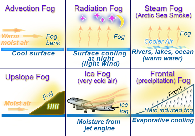
Six types of fog where temperature and dew point meet.
Remember dew point will never be higher than temperature. In some scenarios, such as the onset of rain, dew point increases so rain induced fog will occur. Many think it is rain that reduces visibility, but it is the fog that develops between the raindrops that reduces things. Temperature/dew point spreads must be watched for all six types of fog: advection, steam (Arctic), radiation (ground), upslope, rain induced (precipitation) and ice fog.
Dewpoint also plays into carburetor icing. When you are up flying amongst cloud then you should be thinking carb ice. Remember cloud is formed when temperature and dewpoint meet.
*** A rule of thumb to determine cloud bases, multiply the temperature/dew point spread by 400. For example, if the temperature is 16° C and the dew point is 10° C the cloud base would sit around 2400 feet. ***

Leave a comment