Pilots learn to watch out for ominous low pressure systems and troughs and generally welcome highs and ridges. Highs and ridges induce pleasantness, sunny outlooks, fair weather, harmony, a sense of well-being. “Feel high in a high and low in a low.” (Just made that up). But high pressure systems can be massive in area, and because of it, succumb to modifications particularly near their boundaries allowing a low pressure to infiltrate that may pack a surprise. I’ve seen forecasters (including me) move in (forecast) a high pressure center into the area thereby forecasting lots of VMC. It’s a sure bet, or is it? Isobars can kink enough to form a weak surface trough or low due to an upper weather feature. In the winter, these weak surface troughs or lows can spawn and enhance local snow squalls. I’ve seen the forecast of light snow showers give way to snow Armageddon because of a localized enhancement.
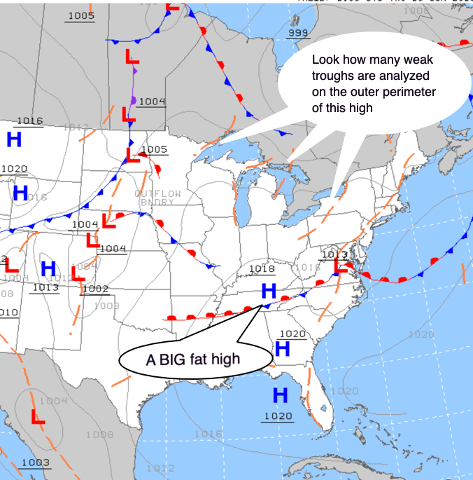
A large high is dominating most of eastern USA and Canada.
There are few isobars typical of a summer scenario.
Lots of localized troughs are analyzed over the Great Lakes.
While taxiing in Toronto, Pearson one winter’s evening, the TAF stipulated a northwest wind with light snow showers. However, a weak low developed over Lake Ontario (the Great Lakes is an area of cyclogenesis due to diabatic heating) and caused helter-skelter as visibility dropped to an 1/8th mile in heavy snow showers. Things went off the rails.
Many times, a low pressure and high pressure systems have tugs of war. A classic wind direction exemplifying this is the northeast wind. This direction can be north of a low or the front of a high. This happens frequently when the high (ridge) is oriented in a southwest-northeast alignment seen frequently in southern Canada along the St. Laurence river basin and the northern states. Pilots have learned a northeast wind in these latitudes should eventually bring IMC conditions. Toronto, Pearson can be using the “sixes” (06 left, 06 right and 05) for days on end under fantastic VFR conditions. The same tug of war scenario is when the low tracks south spreading northeast winds. If it decides to track a little further south, it means it will miss the area perhaps sparing the region of a foot of snow.
A high tends to be a bully in weather by blocking lows. It is like Fort Knox thus reluctant to be infiltrated. But as mentioned, its massive presence gives way to surprises. The front of a high, center and back portion can cause different weather scenarios so you should ask where you are in relation to it. Just because high pressure is in the area, don’t assume everything will be copacetic. Strictly speaking, a high is void of weather i.e. there is no weather but I hope you are now realizing you should be asking, what surprises might I incur?
Given the usual stable conditions under high pressure, you can sometimes get hazy skies during the summer months especially in the southwest flow behind the high. The high is moving onward with another low moving in. But be sure to look up and observe the overriding high cloud, a great time to fly.
High pressure areas often provide the perfect environment for an overnight radiation fog event – clear skies and light winds. Be leery when clear skies prevail over a snow-covered terrain hovering around zero Celsius. The air becomes saturated from sublimation.
If you fly in Europe during late fall and winter months expect lots of low stratus ceilings and fog due to winter time highs. Frankfurt, Paris, Amsterdam and Zurich will be inundated under IMC so the heavy hitter CAT II and CAT III autolands may be in store.
Decks of low cloud capped by a subsidence inversion can be nuisances. You’ll experience ceilings at 2,500 to 3,500 AGL and they won’t budge. The forecaster may expect sunny conditions to prevail, but the subsidence inversion turns out stronger than expected thus capping the cloud a little longer. You may not be able to go to the training area and practice upper air work but this MVFR cloud layer is great for work in the circuit – provided the winds aren’t too strong. Another thorn when learning to fly.
Nowhere is a subsidence inversion more evident than New Delhi, India, the world’s most polluted city during the winter. Visibility will reduce to near zero under smog (they call it smoke in the METAR) as farmers burn crop stubble with people building fires to keep warm and to cook. And watch the poor air quality values shoot off the charts! This inversion is about 2,000 feet thick, about the altitude you start smelling Delhi. Your layover clothes will stink and you’ll be breathing an equivalent to smoking two or more packs of cigarettes a day. Don’t get me wrong, I love India as it has many layers, but their air needs fixing. If you ever meet me, ask me about the “shoe shine boy” squirting caca on my shoes during my first visit.
Air mass thunderstorms can also be a significant issue amongst a high. Many will be scattered, but can be a hindrance. Sometimes the entire high is under siege with air mass thunderstorms, so expect a convective SIGMET.
Lake or sea breezes, which are localized phenomenon, may set up especially as the isobars become sparse giving way to light winds. You may expect a westerly wind typical of a high, but due to a strong lake or sea breeze a 10 to 15 knot flow may set up blowing from the opposite direction. The Great Lakes during spring and early summer will have you scratching your head as you fly along the land/water boundary. If you hear the public forecast talk about very warm temperatures inland, but much cooler along the coast, then think lake or sea breeze. And remember, a lake or sea breeze can advect in stratus and fog, another curve ball.

A humungous high pressure is dominating the summer scenario. Lake breezes have set up over Lake Ontario. They are enhancing convective cloud. Looking south from my condo is upstate New York.
When a high moves in, or builds (intensifies) behind the cold front, expect strong surface winds because isobars can pack (get close together) so mechanical turbulence may ensue. Pilots assume when the cold front has passed, meaning the low has exited stage right, everything is kosher. Nope. That brisk flow can be very unstable as it picks up moisture over open water.
As well, orographic turbulence (mountain wave) may set up from the prevailing westerly wind aloft as many of our mountain ranges in North America are north-south oriented meaning the flow is perpendicular to the ranges.
In the winter, think altimeter errors due to cold temperatures. During summer, heat waves and smog can sit for days. Generally, a high is what you want to see on the weather map, but just remember, dubious highs can delude and lure pilots and deceive weathermen. Sorry to debase the mysticism of a high.

Leave a comment